Ecuador is one of the most biodiverse countries on earth. In a country no bigger than the US state of Nevada, we find stunning diversity. From the majestic Andes to the lush Amazon, and from the otherworldly Galápagos to the verdant Coast, Ecuador is brimming with life.
This is the country where Darwin found the inspiration for his Theory of Evolution. Where the Constitution secures Rights for Nature – a world first. Where more than twice as many bird species can be seen as in the whole continent of Europe. Where local and indigenous communities are stepping up against oil companies to protect their forests. And, sadly, where the rate of deforestation is among the highest of all South American countries.
It would be a shame for the world and Ecuador alike, if this biodiversity haven were lost.
What makes Ecuador so incredibly diverse? First of all, it is located right on the equator (hence the name Ecuador). Species diversity is much larger here than in temperate zones. However, what really makes Ecuador unique, are its four very different ecoregions: the Andes, the Amazon, the coastal plains, and the Galápagos islands.
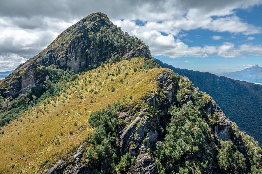
The longest mountain range on earth runs right through Ecuador, dividing the country from north to south. The Sierra consists of a western and an eastern range, with many unique and different species on both sides. The alpine páramo gives way to vast stretches of cloud forest as the Sierra slopes down towards the lowlands. As the altitude changes, species do as well, leading to incredible diversity. The valleys in between the two ranges are highly fertile and have been farmed for millenia. Iconic animals include the Andes Condor, the Spectacled Bear and the olinguito.
To the east of the Andes, the mountains give way to the largest rainforest on Earth, the mythical Amazon rainforest. Several major rivers shape the landscape in this region, such as the Napo and the Coca. After meandering for hundreds of kilometers, they eventually feed into the mighty Amazon river. This stream is so big, it carries one-fifth of all the earth’s fresh water to the ocean. The Ecuadorian Amazon is actually one of the most biodiverse parts of this rainforest. Iconic animals include the Harpy eagle, jaguar and pink river dolphin.

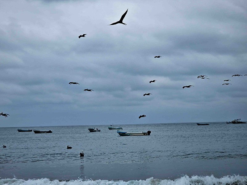
Between the Andes and the Pacific lies the Costa, the coastal lowlands. This region used to be covered by rainforests, dry forests, and mangroves, but gradually the trees have been replaced by farmland. A staggering 98% of the original forest cover has been lost. The many mangroves at the river mouths are under threat of being converted to shrimp plantations. Iconic animals include the howler monkey, Chocó toucan, and humpback whale.
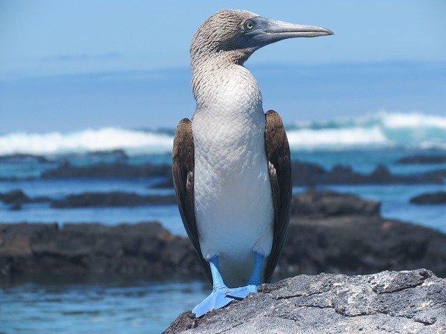
The Galápagos archipelago is another world. Located almost 1,000 kilometers off the Ecuadorian coast, life on these 127 islands is unlike anywhere else on earth. You’ll find giant tortoises crawling on land, large lizards (iguanas) in the sea as well as on land, and no less than 17 different Darwin finches, who all adapted differently to the circumstances on the different islands. The seas are teeming with wildlife because different nutrient-rich ocean currents collide here.
Ecuador is one of the megadiverse countries
Ecuador ranks 9th among the 17 so-called megadiverse countries. If you were to account for its small size, Ecuador even has the highest number of species by area. It hosts about 16% of the world’s birds, 8% of amphibians, 18% of orchids, and 8% of all mammal species.
Two of the world’s Biodiversity Hotspots meet in Ecuador: the Tropical Andes and the Tumbes-Chocó-Magdalena Corridor. The Tropical Andes has been declared the most biodiverse hotspot in the world, hosting many species found nowhere else. In total, 91 different ecosystems can be found in this small country.
Many emblematic species live here. Just to name a few: the Andes Condor, the largest raptor in the world and a national symbol of Ecuador; also called the King of the Andes. The jaguar, the largest cat in the Americas and apex predator, although declining in numbers. The pink river dolphin, comes in all shades of pink, the largest freshwater dolphin, with a huge brain that’s 40% larger than a human’s.

For many years, Mindo (in the Ecuadorian cloud forest) held the record for the highest number of bird species on one day, during the Audubon Christmas Day bird count. Over 400 bird species were sighted in just 24 hours’ time. A testament to the great biodiversity of Ecuador!
Here are some of the numbers of Ecuador’s nature:
There’s a lot of nature to protect in Ecuador! There are three main methods of conservation: Protected Areas by government (SNAP), the Socio Bosque program, and private reserves.
In Ecuador, protected areas make up about 20% of the country’s territory. They fall under the highest protection category according to national environmental laws and, according to the Constitution, are part of one of the subsystems of the National System of Protected Areas (SNAP in Spanish). These areas are spread throughout the mainland and islands.
In total, the SNAP systems consists of 51 protected areas. Not all areas enjoy the same level of protection. There are 11 national parks, but also many ecological reserves, biological reserves, and even national recreation areas. The first protected site was the Galápagos in 1959. The largest is Yasuní National Park with 10,227.36 km2 in the Amazone rainforest.

In Ecuador, forest plots are constantly for sale.
The National Government, following its National Development Plan to reduce the deforestation rate by 50%, launched the Socio Bosque Program in 2008. The program’s main goal is to protect native forests and páramos across the country.
Socio Bosque provides financial incentives to farmers and Indigenous communities who voluntarily commit to conserving and protecting their native forests, páramos, or other native vegetation. The payments are tied to the conservation and protection of these areas. Participants receive the incentives only after meeting the requirements outlined in an agreement with the Ministry of the Environment.
The Socio Bosque Program has gained international recognition. Peru has developed a similar program, while Bolivia and El Salvador are also working on similar initiatives. Currently, the program protects around 1,058,000 hectares of native forests and páramos, benefiting over 120,000 people across Ecuador. The National Government has invested nearly USD 18 million in the initiative so far.1
However, not all of Ecuador’s nature and biodiversity are protected by SNAP. No less than 68% of the priority areas for biodiversity, fall outside the SNAP system (source: Cuesta et al). They are not owned by government.
Who does own these natural areas, then? The answer: private landowners, organizations and, very importantly, indigenous communities. Together, they own about 60% of all Ecuador’s forests. This is much higher than the global average, where 73% of forests are publicly owned.2
Conservation activities in Ecuador cannot be successful without taking the private and indigenous reserves into account.
In Ecuador, forest plots are constantly for sale. This poses problems for conservation: once sold, forest could be turned into pasture or agricultural fields.
However, at the same time this offers a huge opportunity. If a nature organization succeeds in buying the land, together with local partners, it can stipulate in the contract that the area must remain nature. If combined with social activities in the surrounding communities, the forest might actually be protected.
That would be real Impact for Nature.
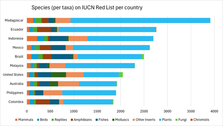
Biodiversity in Ecuador is unfortunately under threat. Ecuador has 2,762 species on the IUCN Red List, which means they are either Critically Endangered, Endangered, or Vulnerable. Globally, only Madagascar has more threatened species on the Red List.
The vast majority of Ecuador’s Red List species (2,074 in total) are plants. Endemic plants, which do not live anywhere else, are even more vulnerable. No less than three quarters of all endemic plant species in Ecuador are threatened.3, 4
One major threat to biodiversity is habitat loss. Between 1990 and 2020, 15% of Ecuador’s forest cover has been lost.5 Together with Brazil, that is the highest percentage of all Amazonian countries. Some of Ecuador’s natural areas are even among the most threatened places on Earth.
Let’s have a look at the deforestation hotspots in Ecuador.
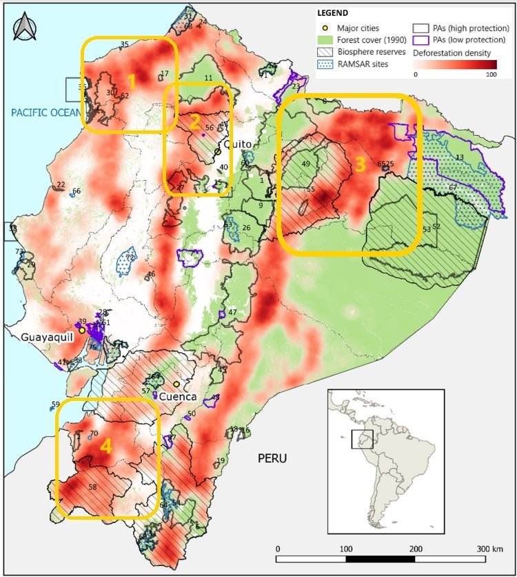
The map shows the forest cover in 1990 in green. Deforestation between 1990 and 2018 is shown in red. The darker the red, the more deforestation took place. The map comes from Kleemann et al., 20226. We added four deforestation hotspots: 1) the moist forests of Esmeraldas; 2) Chocó Andino of the western Andean slope; 3) northern part of Amazon rainforest; 4) southern dry forests.
Even protected areas are not safe from logging.
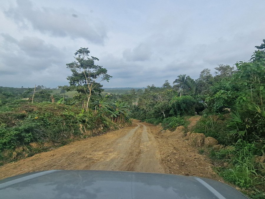
The (very) wet forests of the Chocó ecosystem in Esmeraldas are among the most biodiverse places of the country. This is one of the least developed regions of Ecuador, and some places remain very remote and inaccessible. Still, as the local population increases, so does the pressure on the land. Many forests are being converted to agricultural fields, including inside the protected area of Mache-Chindul.
Unfortunately, the largest rainforest on earth also experiences the highest numbers of deforestation in the country. Since 1985, the Amazon lost 500,000 hectares of natural areas. It started in the northern mining town of Lago Agrio, but currently the area between Baeza and Coca is most affected. 46% of the total agricultural expansion in Ecuador occurs in Amazonia. Over the last 40 years, human land use in the Ecuadorian Amazon increased by 154%.7, 8 And there are few signs of improvement. In fact, between 2021 and 2022 legal and illegal mining increased by one-fifth.
On the western slopes of the Andes there is higher population pressure than in the east, and more forest has been cleared over time. The remaining cloud forests are crucial to protect the often endemic plant and animal species. The highest rates of deforestation can be found in and around the Los Illinizas Ecological Reserve – an indication that even protected areas are not safe from logging.
The deciduous dry forests and premontane evergreen forests of the south have been getting less attention than the moist forests of the north. However, they are also unique, with high levels of endemism, and they are threatened. Between 1989 and 2008, the deforestation rate was an alarming 2.89% per year.9 Most forests have been converted into cattle pastures. The fragmentation of these forests is very high, making the urgency (and difficulty) of conservation equally high.
Forests in Ecuador are mainly impacted by land use changes caused by farming, livestock pastures, urban growth, infrastructure development, mining, and oil extraction. One study10 measured the correlation between different indicators and deforestation. They found that three indicators are the key drivers of deforestation in Ecuador:
Agriculture, including pastures for cattle, is the main driver of deforestation in Ecuador. The country remains highly dependent on agriculture, with 31% of the national workforce active in this sector.11 In rural areas, this percentage goes up to 65%.
In the Ecuadorian Amazon, farming provides nearly 60% of income. Most land is used for livestock pastures and crops. Permanent crops like African palm, cocoa, and palm heart are major causes of deforestation. Temporary crops include corn and cassava.
On the coast, especially in Esmeraldas Province, most of Ecuador’s palm oil is produced. Farming here focuses on livestock pastures and permanent crops like African palm, cocoa, and bananas for export.
In the Andes, smaller-scale farming drives deforestation. Land is used for livestock pastures and temporary crops like corn, potatoes, and barley, as well as permanent crops such as sugar cane, cocoa, tree tomato, and piedmont heart palm.
Roads provide access. Without roads, forests are more difficult to reach, and disturbances tend to decrease. Ecuador has high infrastructure growth in and around protected areas, putting pressure on these areas due to the lack of buffer zones and corridors. Currently, 22% of Ecuador’s forest ecosystems are listed as threatened on the IUCN Red List of Ecosystems.12
Mining, especially for oil, has been a major promoter of economic growth in Ecuador. Mining laws were basic until 1937 when underground metals were declared state property. Environmental laws for mining only appeared in 1991. These laws limited concessions in protected areas and required environmental impact studies for all mining activities.
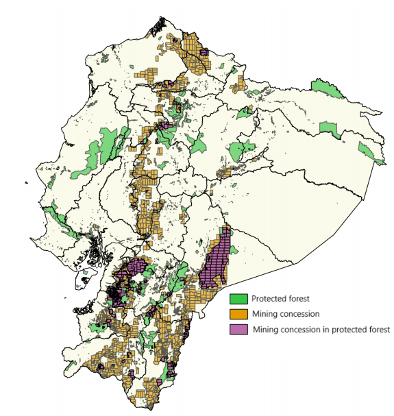
In 2016-2017, the Ministry of Mining increased exploratory concessions from 3% to 13% of Ecuador’s surface area. Protected Forests (Bosque Protectores) are not excluded. One third of the Bosque Protectores are now part of an exploratory mining concession, leaving them at risk.13
In 2023, Ecuador made global headlines with the outcomes of a national referendum on oil drilling in the Amazon. Despite the potential economic benefits, 60% of the population voted against further mining activities. In the highly biodiverse Yasuni National Park, 700 million barrels of crude oil have to remain in the ground.
Ecuador is one of the most biodiverse countries on earth. It boasts four different regions: the Coast, the Andes, the Amazon, and the Galápagos. Each of these regions has its own unique wildlife. If you were to account for its small size, Ecuador even boasts the highest number of species by area. It hosts about 16% of the world’s birds, 8% of amphibians, 18% of orchids, and 8% of all mammal species.
Nature is protected by government reserves (PANE), the Socio Bosque program, and private and indigenous reserves. 60% of all nature is privately owned (including indigenous reserves and NGOs), and land is constantly for sale. This creates risks but also offers opportunities for conservation.
Ecuador’s nature is under severe pressure. Only Madagascar has more threatened species listed on the IUCN Red List. Between 1990 and 2020, 15% of Ecuador’s forest cover was lost. The coastal forest has been reduced by 98%. The main drivers for deforestation are agriculture, roads, and mining.
Even though there is reason for concern, there is also hope. Two-thirds of Ecuador’s land cover remains natural to this day. It is up to all of us to protect it.
Do you want to make an Impact for Nature and help protect Ecuador’s biodiversity?
Click the button to get started!
1. Ministry of Environment, Ecuador. Link to website.
2. FAO, Global Forest Resources Assessment 2020. Link to report.
3. Freire-Fierro et al., 2024. Google Scholar
4. IUCN Red List. Link to website.
5. FAO, Global Forest Resources Assessment 2020. Link to report.
6. Kleemann et al., 2022. Link to article.
7. Brown, 2024. Article from Mongabay.
8. Mapbiomas Ecuador – Amazonia. https://ecuador.mapbiomas.org/
9. Tapia et al., 2015. Link to article.
10. Kleemann et al., 2022. Link to article.
11. World Bank. Link to website.
12. Noh et al., 2020. Link to article.
13. Vandegrift et al., 2017. (Rainforest Information Centre). Link to article.
Dream big, start small
Leave your email and
be the first to receive updates!